Drones
Seven promising applications for drones
How drones support firefighters, farmers, and archaeologists in their work.

Drones
How drones support firefighters, farmers, and archaeologists in their work.
23 January 2020
More than half a million drones are already in the air in Germany – mostly for private purposes. But the number of drones in use for professional purposes in Germany is also growing rapidly and is projected to climb to 42,000 by 2021. But it isn’t only photographers and filmmakers who account for the increasing popularity of these unmanned flying objects. Firefighters, farmers and archaeologists are also looking in ever greater numbers for aerial support in their work.
Firefighters work in dangerous environments. And they are now also calling for aerial support to give them a better overall view of the dangers they face when they are called out. Drones equipped with thermal imaging cameras can seek out fire hotspots and be used in dangerous or inaccessible places to relay information back without any need to risk human life. These unmanned aircraft with their infrared cameras can also help in the search for missing persons. For instance, they can track down people who have been thrown from their cars and who would otherwise be found too late, either because it’s dark or they are hidden in the undergrowth. Another idea is to use swarms of autonomous drones to measure the spread of toxic gases in the wake of fires or accidents as a way of protecting the local population more effectively – a procedure which the Dortmund fire brigade has already trialled in the “AirShield” research project of the Federal Ministry of Education and Research. To make it easier to offer aerial support to the emergency services on the ground, such swarms are subject to the special rules laid down in German legislation on drones. They are not required to notify the authorities in advance of the use of the unmanned aircraft and are permitted to fly drones weighing up to five kilos outside visual range, for instance to map the terrain behind a column of smoke. However, third parties are not allowed to fly drones over places where the fire brigade is at work. In other words, the airspace over an incident is strictly out of bounds for professional or private rubberneckers.
Bygone cultures often built their settlements, houses or tombs in places which are difficult to get to. In such cases, drones are considered a cheap and practical alternative to satellite images and helicopters. They can be deployed to get a bird’s-eye view of an excavation site, for instance. In the Altai mountains in Russia, archaeologists used pictures taken by drones to generate 3D maps which allowed them to determine the size of the burial mounds they had found there. In the US state of New Mexico, drones helped researchers in their efforts to excavate a city built by the Pueblo Indians. They used their infrared cameras to locate walls hidden in the earth, thereby giving the scientists important information about where to start digging next. Researchers from Berlin and Dresden used their Archaeocopter to make 3D maps of Karakorum, the former capital city of the Mongol empire, temple complexes erected by the Huastecs in Mexico and the mausoleum in Algeria of King Juba II of Numidia. And yet, archaeologists don’t just look for traces of vanished cultures from the air. They also use underwater drones of their own invention to determine, for instance, the extent to which the ravages of time have eaten away at the lake dwellings originally built on stilts by Neolithic people in Lake Mondsee in Austria – with the aim of using these findings to preserve this world cultural heritage site more effectively for future generations.
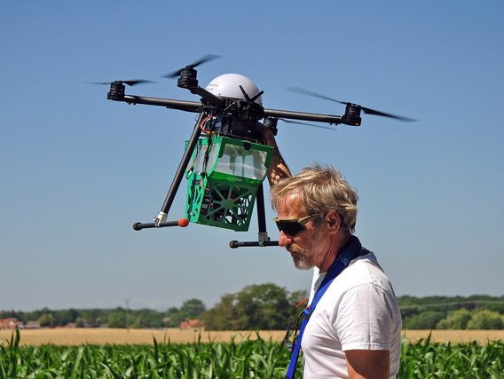
Drones have also been pressed into service over fields and meadows. There they are used to gauge the health of plants; their infrared cameras can also help detect the presence of fawns in a field before mowing, and they can be used to pinpoint patches of weeds from above. They are also deployed with biological weapons to fight pests such as the European corn borer: As part of a pilot project, the Saxony-Anhalt State Institute for Agriculture and Horticulture arranged for larvae of the Trichogramma parasitic wasp to be rained down on the eggs of this small butterfly by drone with the aim of putting a natural end to this corn-eating pest. The agricultural insurance company Vereinigte Hagel also flies unmanned aerial vehicles over corn fields. These help detect severe weather damage from the air; a task which is often very difficult when conducted on foot among plants that grow to the height of a man. Drones equipped with multispectral cameras can determine plant growth and, with it, the nitrogen demand of a field. This allows farmers to apply fertiliser exactly where it is needed. This both saves money and is good for the environment.
What the talking refrigerator is to the Internet of Things, the courier drone is to unmanned aerial systems: a first tangible example of the specific benefits of the new technology. In December 2013, Amazon CEO Jeff Bezos promised that customers would be receiving their orders by drone in four to five years. But, to this day, “Prime Air” has not gone beyond the test flight phase. These high-flying plans ran up against regulatory hurdles and technical problems, although the online giant claims at least to have sorted out the latter. In mid-2019, a new drone was unveiled which will fly a good 24 kilometres and deliver packages weighing up to 2.3 kilogrammes in less than 30 minutes. In the next few months, Amazon aims finally to launch its drone delivery service. Google's parent company, Alphabet, has already gone one step further. After years of testing, Alphabet has been delivering regular goods by drone in Canberra, Australia, since April 2019. With the approval of the US Federal Aviation Administration (FAA), its Wing subsidiary also launched a field trial in Christiansburg, Virginia, in October last year. Since then, customers of the transport service provider FedEx, a drugstore chain and a local confectionery store have successfully been supplied from the air with packets of up to 1.5 kilogrammes in weight. The devices are controlled by several pilots on the ground.
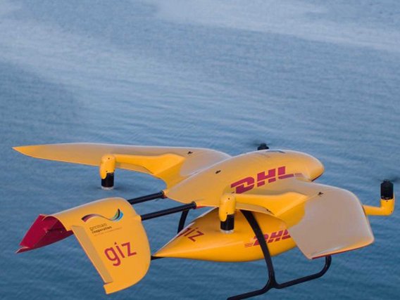
Deutsche Post subsidiary DHL has also been experimenting with airborne delivery for some years. In the autumn of 2014, a DHL drone flew drugs and express goods to the North Sea island of Juist for the first time. Since then, the delivery company has also been testing the technology in the Alpine resort of Reit im Winkl and on Lake Victoria in Africa. In May 2019, the first inner-city route went into operation in China. Twice a day, unmanned aerial aircraft in the city of Dongguan transport boxes containing express shipments weighing up to five kilogrammes over an eight-kilometre route between two packing stations – completely without human intervention. Instead of being driven in a van for 40 minutes through city traffic, it is claimed that the express deliveries can reach their destination in eight minutes. DHL intends to offer this airmail service in other Chinese cities as well. In Europe, on the other hand, no regular delivery operation is planned. Drones are “a pure research project for the time being”, a company spokeswoman said. The rules that govern drone use are strict. They often have to be grounded in bad weather conditions, and the German logistics industry is unanimous in its assessment that they are in any case not suitable for mass shipping. DHL is therefore concentrating on special applications such as drug transportation in Africa.
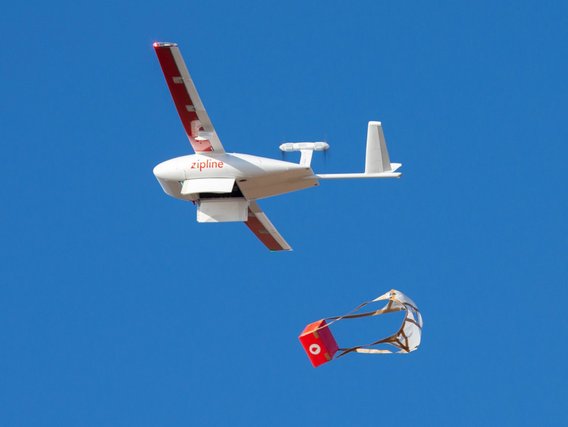
In Africa, Californian start-up Zipline has been supplying medicines and blood bags from the air since 2016. Since then, according to the company, more than 27,000 life-saving aid packages have been dropped by autonomous drones: most of them in Rwanda, where remote hospitals are supplied with donor blood. The drones travel at 100 kilometres per hour and can deliver their blood bags within a radius of 80 kilometres in 45 minutes or less. Cars or motorcycles would take much longer on the poorly developed road network. The self-developed drones are more reminiscent of large model aircraft: the familiar quadcopters would simply be too slow, and their high energy consumption would limit them to much shorter distances. To make them as efficient as possible, the Zipline drones are catapulted into the air from a ramp, drop their packages at the destination under parachutes, and are then whipped out of the sky by cables at the logistics centre and kitted out with fresh batteries. Since 2019, Zipline has also been delivering vaccines, blood and medicines from three logistics centres in Ghana, and this number will in time increase to five. This year, the company, in which U2 singer Bono now owns a stake, plans to launch in India and the Philippines. A pilot project in the US state of North Carolina is also seeking to determine whether and how autonomous drones can be integrated into airspace surveillance systems over conurbations so that they endanger neither other aircraft nor people on the ground as they ply their delivery routes.
Drones are particularly popular for inspections. After all, human inspectors have often had to climb to dangerous heights in their work; either that, or it has simply taken ages to scrutinise that last inaccessible corner of a plant. (TÜV NORD uses unmanned aerial vehicles, for example, to monitor railway infrastructure. The drones fly over tracks, bridges and structures, recording changes and damage with their HD and infrared cameras for later evaluation by human experts.) In the EU-funded “Aeroarms” research project, safety experts from TÜV NORD are developing a complex inspection system in cooperation with the University of Seville and the German Aerospace Center. At its heart are drones equipped with robotic arms which can set down a test crawler equipped with sensors on refinery pipelines, for example. This crawler then examines the pipelines for wear or damage. Until now, time-consuming health and safety measures and complicated scaffolding have always been needed for human inspectors to reach the pipes in the first place.
Nowhere in the world are more people killed, injured or mutilated by mines than in Afghanistan. The treacherous thing about the butterfly mines dropped in the country in their millions by the Soviet army in the 1980s is that their shape and coloured paintwork often fool children into mistaking them for toys. And because they are mainly made of plastics, they are virtually impossible to find with metal detectors. According to US researchers, the idea in this case is for drones with infrared cameras to come to the rescue. Liquid explosives heat up faster than the environment and cool down more slowly in the evening, meaning that drone-mounted thermal imaging cameras can capture them as a “thermal anomaly”. In the pilot phase, the images are being evaluated manually by the researchers. In the future, however, the process will be automated using algorithms. Afghan-born engineer and designer Massoud Hassani wants to use his own invention, the Mine Kafon Drone, to defuse classic landmines. First of all, a drone creates a 3D map of the environment. Another drone then flies over the area based on the data and uses its various sensors to detect mines, which it then blows up using a detonator. This method is said to be safer and cheaper than conventional methods – and will thus be ideal for ridding the world much faster of the many millions of as yet undetected mines.
This is an article from #explore. #explore is a digital journey of discovery into a world that is rapidly changing. Increasing connectivity, innovative technologies, and all-encompassing digitalization are creating new things and turning the familiar upside down. However, this also brings dangers and risks: #explore shows a safe path through the connected world.