Sustainability / Innovation
Forest inventory from space
How AI captures natural resources with satellite data.
Sustainability / Innovation
How AI captures natural resources with satellite data.
June 23, 2023
The company Global Surface Intelligence has developed a process that creates accurate and current inventories of forests using artificial intelligence and publicly accessible satellite data. This not only opens up exciting possibilities for forest owners. The underlying technology is also intended to capture and measure other resources in the future and thus, for example, document crop failures for insurance companies.
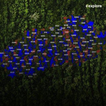
The radar satellite Sentinel-1A orbits the Earth at an altitude of 700 kilometers. Since 2014, it has been taking countless images of the Earth's surface day after day. Together with other satellites, it is part of the Copernicus program. The joint project of the European Commission and ESA operates remote sensing: It delivers data on the state of the Earth's surface, several petabytes daily. This data is publicly accessible, meaning anyone can use it freely. The Edinburgh-based company Global Surface Intelligence (GSI) has developed a process that extracts valuable information for forest owners from this flood of data. For this, the Scots use artificial intelligence and machine learning.
If previously someone wanted to know how many trees and which species exist in a certain area, then humans had to count the trees – on aerial photos or on site. However, this method is very inaccurate, it is also expensive and simply not practical for large forests. In North America, there are commercially used forests with an area of several thousand hectares that produce wood for many industrial purposes. With the remote sensing platform developed by GSI, the owners of such forests can also receive real-time information about their stocks – and regularly, repeatably and automatically.
"We don't just capture the number of trees," explains Peter Young, CEO of GSI. "We also provide information on the species, height and diameter of each tree." Such data is not only important for traditional forestry, but also for a relatively new business model: "More and more companies are looking for ways to compensate CO2 emissions as part of their sustainability goals," explains Young. "Forests are excellently suited for this." How much CO2 a tree can store depends on its species, size and age. "We first identify: Where are there suitable forest areas at all? In which area are there which types of trees at what maturity, height and with what diameter?" says Young. "Then we approach the forest managers and ask if they want to offer the area on a CO2 compensation platform."
To evaluate the huge raw data volumes of the Sentinel satellites, GSI also uses the supercomputer of the University of Edinburgh. GSI supplements the remote sensing data from the satellites with additional information, for example from drone recordings. The company founded in 2012 today has 15 employees, including specialists in environmental and data sciences as well as people with experience in programming or in the space industry. Like Peter Young, who was CEO of one of the largest British space companies for eight years before GSI.


In 2022, TÜV NORD GROUP participated in GSI through ALTER TECHNOLOGY (ATN). ATN represents the Aerospace business unit within TÜV NORD GROUP. With the investment, Young and his team want to further expand the business with forest inventories.
Additionally, GSI is developing further applications for the company's technology: "We are also looking at how we can use remote sensing in other business fields and industries, for example to document crop failures for insurance companies," reports Young.
Stephen Duffy is Managing Director of ALTER TECHNOLOGY UK, a subsidiary of ATN, and has been Investment Director on the board of GSI since autumn 2022. He sees great potential for the investor in the combination of remote reconnaissance, AI and machine learning: "In TÜV NORD GROUP, much revolves around testing, inspections and certifications," explains Duffy. "With GSI, some of these tasks can be handled by AI in the future."
This is an article from #explore. #explore is a digital journey of discovery into a world that is rapidly changing. Increasing connectivity, innovative technologies, and all-encompassing digitalization are creating new things and turning the familiar upside down. However, this also brings dangers and risks: #explore shows a safe path through the connected world.