13. January 2022
They’re well known for being indispensable in automated vehicles, but LiDAR sensors are also already providing important services in other areas. Christine Peeck from TÜV NORD explains what’s behind the technology and how it is also helping, for example, in the planning of wind farms.
What is LiDAR?
LiDAR stands for “light detection and ranging”. Unlike their better known relative, radar, LiDAR systems work with laser beams rather than radio waves. They are used, for example, to create high-resolution three-dimensional maps – for applications including mining, geology, archaeology and seismology. LiDAR sensors also play a key role in automated vehicles. In combination with radar, ultrasound and cameras, they provide information about where objects are located in the vicinity of the vehicle. LiDAR can also be used to measure atmospheric parameters, such as the concentration of water vapour or trace gases such as nitrogen oxides, sulphur dioxides or methane. This is useful for determining, for instance, whether the statutory emissions limits are being adhered to by industrial plants. LiDAR systems are also fundamentally suitable for exploring the atmosphere and the surface of the Earth from space. However, this poses major challenges for the technology. For this reason, the staff at Alter Technology have developed a method for testing LiDAR sensors for possible use in satellites.
You’re using LiDAR for site surveys for wind turbines. How does that work exactly?
We use LiDAR to measure wind speed. The conventional instrument for these kinds of measurements is the anemometer. In principle, this consists of a mast on top of which you have a set of rotating spherical shells. The wind is measured at exactly this point, i.e. locally. LiDAR systems, on the other hand, work with light and allow measurements to be taken from a distance. The light rays have a certain wavelength that can be adjusted – and then you know how long the light takes to get from A to B. As they travel, the light rays collide with tiny, suspended particles, known as aerosols. Since the coronavirus pandemic hit, these have become well known to us as microdroplets, but they can also be particles of dust or soot particles from a car exhaust. These aerosols reflect the light and send it back to the LiDAR device. The Doppler effect can then be used to determine how fast this dust particle is moving up in the atmosphere, in other words, how hard the wind is blowing.
„The nice thing about LiDAR technology is that wind speed can be reliably measured from ground level at a height of up to 200 metres.“
What are the advantages of this?
The nice thing about LiDAR technology is that wind speed can be reliably measured from ground level at a height of up to 200 metres. Newer wind turbines have hub heights of over 160 metres. Setting up a classic measuring mast with an anemometer at such a height requires a huge amount of effort. You need a building permit and loads of space and time for the installation work – and if a piece of equipment breaks at the top of the tower, someone has to climb up to fix it. The LiDAR system we use, on the other hand, is a compact cube of 60 by 60 centimetres that can be transported and operated in a small trailer. You can drive it onto the field without any fuss and start measuring once you get there. We’ve been working with this method for a good five years, initially with borrowed devices or in cooperation with other measuring institutes. Since the autumn of last year, we’ve also been using our very own LiDAR device for the first time.
© VISIONPLUS CO., Ltd.The LiDAR system, a compact cube measuring 60 by 60 centimetres, seen here in South Korea.

Is the system then controlled on site or digitally?
This system is operated completely autonomously on site using solar energy and a fuel cell. In other words, you don't need any power cables. Three solar panels feed a battery that heats and supplies the LiDAR device with power. If the sun isn’t shining strongly enough, the methanol-powered fuel cell steps in. We can then access the device remotely online. All we need is a 4G mobile network or some other means of access to the Internet. If a leaf falls on the sensor and blocks the laser beam or some other fault occurs, the system sends an email. I can even operate the wiper which sits on the lens on the front from the office. This means that we only rarely have to go out to top up the methanol for the fuel cell or add water to the screen wash. And you can in any case train a local farmer to do both of those things. This makes operating the system even more cost-effective.
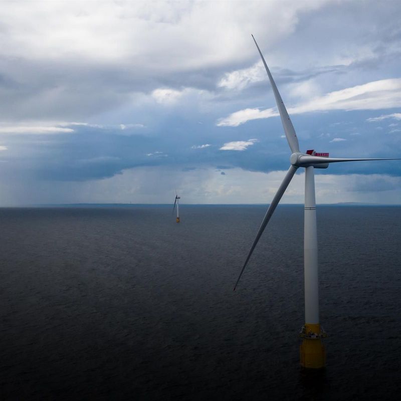
And does this also work when it comes to planning offshore wind turbines?
Yes, it absolutely does. In this case, the LiDAR system is installed on a floating platform. Wind measurements, whether onshore or offshore, aren’t generally carried out for just a few days, but usually over at least twelve months. After all, we want to determine the wind conditions over the entire course of the year – from April storms through to light summer breezes. This is the only way to reliably predict what the planned wind turbine will produce in real operation. This is also a financial factor for the planners and operators of wind turbines: since 2017, anyone wanting to participate in a tender under Germany’s Renewable Energy Act (EEG) has been obliged to provide proof of the suitability of the envisaged site. In these site surveys, they also have to indicate how many kilowatt hours of electricity these plants will generate per year. They will then receive a certain amount in eurocents per kilowatt hour via the EEG feed-in tariff. However, if it turns out during operation that these plants are generating power less efficiently than was estimated, the operators will have to repay the additional amount, with interest. And if they can use exact measurements to deliver the most accurate forecasts possible, they will be able to avoid these costs in advance.
About Christine Peeck
© TÜV NORD

Christine Peeck is Vice President Wind & Technical Site Assessment at TÜV NORD. The trained meteorologist takes care of the site surveys that are required before the construction and during the operation of a wind turbine. She works with her colleagues on site to determine the local wind potential. Her job also includes assessing whether the planned turbines could affect local residents and wildlife as well as other wind turbines.