Geothermal Energy
Heat From The Depths
How deep geothermal processes extract heat from the earth.
Geothermal Energy
How deep geothermal processes extract heat from the earth.
13 October 2022
Over half of all the energy consumed in Germany is used for heating – for instance, for hot water, offices or industrial processes. And 84 percent of this energy is derived from coal, oil and gas. If we are going to achieve the target of making the supply of heat up to 50 percent carbon neutral by 2030, then some things will have to change. Geothermal energy is seen as a promising option here. And yet, little use has been made of heat from the depths – until now.
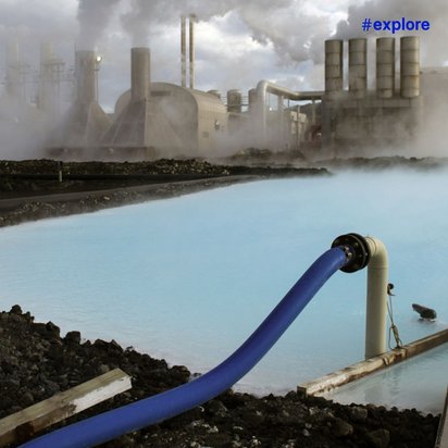
The future of heating is playing out discreetly in the background in Munich’s “Süd” thermal power station. Beneath the flues of this gas-fired power station a new geothermal plant has been running in test mode since the summer of 2021 – according to Munich’s public utility company, it is the biggest in Germany and one of the most modern in Europe. Thermal water at a temperature in excess of 100 degrees is pumped up from a depth of 3,000 metres below ground. This liquid treasure has become enriched in small cavities and fissures in the limestone layer which dates back over five million years.
Once it reaches the surface, the hot water is carried in large pipes to heat exchangers. These extract the heat from the thermal water, and that heat is then transferred into the district heating grid. The water from the depths, which has by now cooled down to between 60 and 70 degrees, is then fed back into the limestone layer from which it was extracted. This cycle is thus closed on the surface: climate-damaging constituents of the thermal water, such as CO2 or methane, are not released.
When it is fully operational, the 50-megawatt plant in Sendling will supply enough energy to heat the homes of 80,000 Munich residents. Good for the climate, cheap, protected from price fluctuations and available day and night, all through the year. By 2040 the city aims to cover its entire district heating needs with renewable energy – most of which will come from geothermal sources.
The geothermal plant at the Munich municipal utility’s southern heating plant supplies heat for more than 80,000 people.
The potential of thermal water from the depths of the earth is enormous – such, at least, are the findings of a study conducted by the Fraunhofer Institute and the Helmholtz Association. The hydrothermal geothermal process that extracts hot water from depths of between 400 and 5,000 metres would be sufficient on its own to cover about a quarter of Germany’s heating needs, the researchers maintain.
And yet, whereas 90 percent of the heating energy of the volcanic island of Iceland comes out of the earth, the share in the heating mix of geothermal plants in Germany is still decidedly modest. There are currently 42, not including the new plant in the Munich district of Sendling. Taken together they produce just under 360 megawatts of heating energy and 45 megawatts of electricity – less than is produced in the Cologne-Niehl II gas-fired thermal power plant alone.
To exploit the opportunities presented by geothermal energy and achieve the country’s climate targets, thousands of new boreholes will have to be drilled and plants built in the coming years, say the researchers from the Fraunhofer Institute and the Helmholtz Association.
High-yield subterranean water reservoirs are not to be found everywhere, nor is the temperature high enough everywhere at an accessible depth. Some particularly promising areas that are already being exploited are to be found in the molasse basin in southern Germany. Or in the Rhine rift valley, which stretches from the Swiss border to Wiesbaden and beyond. And in the north German basin which includes large areas of Lower Saxony, Brandenburg and Saxony-Anhalt in addition to Schleswig-Holstein, Hamburg, Bremen, Mecklenburg-Western Pomerania and Berlin.
And whereas in some of these regions the subsoil has been explored, at least in outline, in other places the picture is a completely different one, explains Silke Bißmann, a geologist at TÜV NORD subsidiary DMT. “Many regions with high potential for geothermal energy are currently blank spaces on the map.” Specialist such as Ms Bißmann see improvements to the underlying data inventory as essential to the expansion of geothermal energy. And this has also been written into the coalition treaty by the German government. For its part, North Rhine-Westphalia is hoping to blaze a trail by setting a good example.
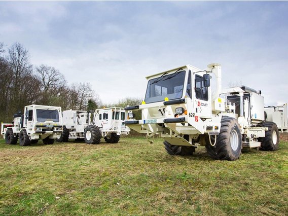
In search of potential: DMT Vibro trucks explore the geothermal situation underground in parts of North Rhine-Westfalia.
From this October, what are known as vibro trucks will be rolling from Viersen via Düsseldorf to Duisburg, where they will be deployed to chart the geothermal situation of the subsoil. The trucks use vibrating plates to generate vibrations in the soil which spread out into the subsoil as sound waves, which are then in turn reflected differently by different types of stone. Thousands of sensors on the surface intercept these signals. The data thus generated are used by North Rine-Westphalia's Geological Service to generate a two-dimensional sectional view of the subsoil.
In 2021, the state government did manage in this way to fill in some of the blank spaces on the map in the Münsterland – in the process also discovering some promising structures in the strata of stone. Heat suppliers, industrial firms and local authorities can now use these data as the basis for their own investigations. And, thanks to 3D seismology (see box), they can also identify suitable places for geothermal plants.
Last but not least, the acceptance of geothermal projects would have to be underpinned by accompanying measures, industry representatives warn. And these are not equally alive and kicking in all places. Since a geothermal drilling operation has been causing minor earth tremors in Basel since 2008, worries about the potential impacts of the technology persist. Although it must be said that hydrothermal geothermal plants such as those in use in Germany are significantly less exposed to earth tremors. “What’s more, high-risk zones in the subsoil can now be identified more easily and plans adapted accordingly,” says Simon Kremers, whose job at DMT focuses on manmade earthquakes. When geothermal plants are operating, seismic activity in the vicinity is monitored by sensor systems. “The risk of creating noticeable earthquakes is very low, but not zero, of course,” says Mr Kremers.
Which why it is essential to offer local people transparent information and to involve them in the planning process, the geophysicist says. What this might look is demonstrated by a geothermal project in the Breisgau, in which a council of citizens, having grilled various experts, came out with a large majority in favour of the planned plant. Many residents would also like to see the project implemented quickly.
At the moment it can take anything from eight to ten years for hot water to finally start bubbling up out of the earth. Speeding up the planning processes, improving preliminary explorations and standardising the construction of geothermal plants would make it possible to shorten this process by two to three years, says Boris Dombrowski from DMT: “And that’s where we need to head if we want to get the heating transition over and done with as soon as possible.”
And yet, even the very best of preliminary explorations cannot offer a one hundred percent guarantee of success. “Every tenth drilling operation fails – in other words, it doesn’t provide enough water at the required temperature,” explains Boris Dombrowski, deputy head of Geo-Energy & Resources and DMT. And, according to Munich’s public utility company, a single drilling operation costs up to 15 million euro. For local heat suppliers, that kind of loss can spell doom, says geophysicist Mr Dombrowski. Many of them are therefore scared off by the risk.
The German government has for this reason now created a federal fund for efficient heating grids, which has since mid-September been supporting geothermal plants, among other beneficiaries, by funding up to 40 percent of their investment costs. From the point of view of industrial associations, while this is undoubtedly a step in the right direction, the sum total of the available funds is still way too low. Not only that, but state-supported insurance to cover the risk of coming up empty handed, as was originally envisaged by the federal government, is also needed, the associations claim. The point of such insurance would be to compensate for some of the losses in the event of failure. “This move would create a level playing field between geothermal energy and other energy sources. After all, a municipal utility has never yet had to worry about the exploration and extraction of gas or oil as raw materials; all they’ve had to do is purchase them,” says energy expert Mr Dombrowski.
This is an article from #explore. #explore is a digital journey of discovery into a world that is rapidly changing. Increasing connectivity, innovative technologies, and all-encompassing digitalization are creating new things and turning the familiar upside down. However, this also brings dangers and risks: #explore shows a safe path through the connected world.